Is it a country or a territory?
A week or so after I started sharing my newly created daily geography puzzle with friends, I got a message about a missing country: "Where's Scotland?". Sure enough; it wasn't on the map! And as I dug deeper into this I found more missing and/or mislabeled countries.
When I initially built the mapping logic, I'd made just one exception: removing Antarctica to make it easier to view and select more countries on the map. The map is rendered using D3 and TopoJSON and I shipped it as early as I possibly could, in the spirit of getting feedback sooner than later. That meant not going too terribly deeply into which countries were and were not included, and how countries and territories overlapped.
I soon realized though that these are the sorts of queries I can't ignore for too long; it's a game about geography after all! So I started tracking oddities with missing and/or contested countries. In working though these over the past week, I've learned that there's an interesting difference between visual delineations of countries on a map, and regions that are technically territories of other countries.
For example, France has a collection of territories that are quite far away from the country itself, and are known as Overseas France. On my initial map, selecting French Guiana would register as "France", which immediately threw people off.
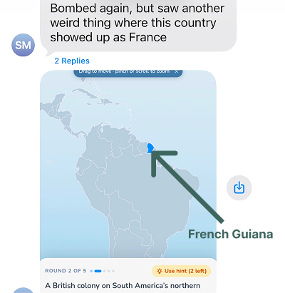
I realized I would need to either find a way to make it clear in the UI when a territory was selected and labeled as the "parent" country, or else change the logic about how I rendered territories completely so as not to exclude them unnecessarily.
Restricting the list of supported countries to sovereign states could certainly simplify the map design a bit, but I worried it would come at the cost of actually helping people learn more about lesser known parts of the world, which is part of why I'm building this game.
So I decided to use the ISO 3166-1 alpha-3 list as my base instead, as this list is a bit larger than those most commonly known as sovereign states. As of today, there are 249 countries and territories on that list. I opted to make a few very specific exceptions:
- Added XKK (Kosovo) as per the EU Guidelines.
- Removed ATA (Antarctica) for map usability (it takes up a significant amount of screen real estate).
- Split GBR into four distinct countries; England, Scotland, Wales, and Northern Ireland. These countries are technically part of ISO 3166-2 but given I have a massive English speaking population playing the game to start with, I decided to go a little deeper for these countries specifically.
In trying to pick which ideas to build, one piece of advice I've gotten consistently is to find an area that you're passionate about. Something that will sustain your interest over the long term. Geography is such a good example of this for me; it's fascinating to get to learn a little more about the world this way.